


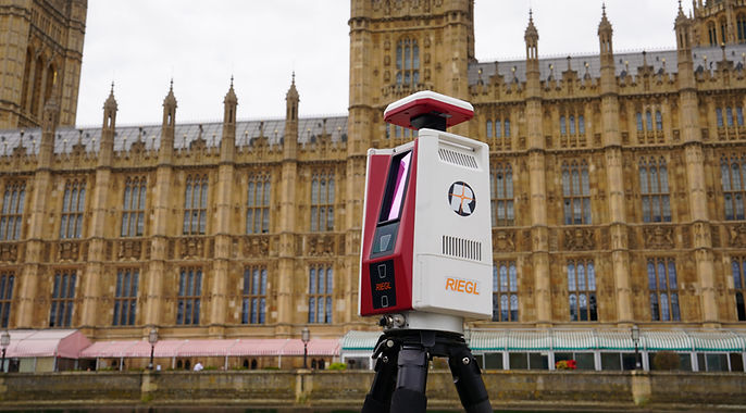
RIEGL VZ-600i
Redefining LiDAR scanning
RIEGL’s VZ-600i delivers rapid, high-precision 3D data capture with intelligent automation, robust performance, and lightweight mobility – redefining what's possible in LiDAR scanning.
This terrestrial laser scanner is trusted by professionals for its rapid on-site setup, millimetre-precision scans, and seamless integration into demanding survey workflows.
The RIEGL VZ-600i in action
Watch how the VZ-600i transforms real-world environments into precise digital twins with speed, clarity, and built-in automation.
Why choose the VZ-600i?

High Productivity
Quickly capture up to 60 scan positions per hour, each with image data and real-time automatic registration. No external tablet needed. With ultra-fast data downloads (up to 500MB/sec) and an easy One-Touch Processing Wizard in RiSCAN PRO, your post-processing is faster, easier, and fully automated, including instant PDF reporting.

Ultimate Performance
Get pinpoint precision with 3mm 3D accuracy at 50m, and a scanning range of up to 1,000m. Capture millions of points per second (up to 2.2million pulses/sec), and complete high-resolution scans in just 30 seconds with 6mm detail spacing, ideal for fast, detailed site documentation.

Extreme Versatility
Scan indoors or outdoors with full flexibility. The VZ-600i includes GNSS positioning, three internal cameras, and support for external cameras. Lightweight at just 6kg, it’s portable, powerful, and programmable. You can even run your own Python apps on it.

Additional Mobility
Built for dynamic setups, the VZ-600i integrates with robotic platforms (ROS compatible), supports mobile mapping, and pairs seamlessly with the RIEGL VMR Robotic Rail System. Its modular design allows easy mounting on tripods, vehicles, or rails.
Key Applications for the VZ-600i

Surveying and Mapping
Accurately map complex environments for planning, design, and engineering tasks. The VZ-600i streamlines workflows by automating registration and producing ready-to-use outputs like PDF reports.

Public Safety and Forensics
Document crime scenes or accident sites quickly and thoroughly. Map high-risk areas for pre-event Emergency Planning. Lightweight and easy to deploy, the VZ-600i provides high-quality data that is presentable in court.

Forestry & Vegetation Analysis
Penetrate dense vegetation using multi-echo Time of Flight (ToF) measurements. Reduce blind spots and occlusions while gathering detailed structural and biomass data, thanks to full waveform processing.

Building Information Modelling
Capture precise 3D data quickly across large construction or renovation sites. Easily scan hundreds of positions with sub-centimetre accuracy. Ideal for creating digital twins of buildings and infrastructure.

Railway Surveying
Perform high-speed, precise railway scans using traditional static laser scanning and kinematic function. Fully compatible with RIEGL’s VMR Robotic Rail System and ROS-based platforms for repeatable, high-efficiency rail track inspections.

Architectural, Engineering & Construction
Validate elements like wall alignment, panel placement, vertical accuracy, tunnel surveying, bridge inspection / documentation and blockouts & sleeves. Use during site prep for grading validation and to check roadway construction after completion.

Mobilise Your VZ-600i
Discover the VZ-600i’s easy assembly and high-quality scanning abilities here:

FAQs
How much does the RIEGL VZ-600i cost?
Pricing varies based on configuration and accessories. Contact us using our website form, email info@riegl.co.uk or call +44 (0) 1904 217785 for a tailored quote.
Can the VZ-600i handle outdoor and indoor environments?
Yes. It’s designed for both, with GNSS, cameras, and versatile scanning modes built in.
Is it compatible with mobile platforms or robotic systems?
Yes. The VZ-600i is ROS-compatible and supports mobile mapping setups, including RIEGL’s own VMR Robotic Rail System.
What’s the data processing workflow like?
With RiSCAN PRO’s One-Touch Processing Wizard, you can go from scan to PDF report in a few clicks, fast and automated.
Can I use Survey Control with the VZ-600i?
Survey control can easily be introduced to accurately geo-reference the scan data, and tie to a network.
How fast can the VZ-600i scan a typical site?
It can scan up to 60 positions per hour, each with image capture and real-time automatic registration at the same time as scanning.